
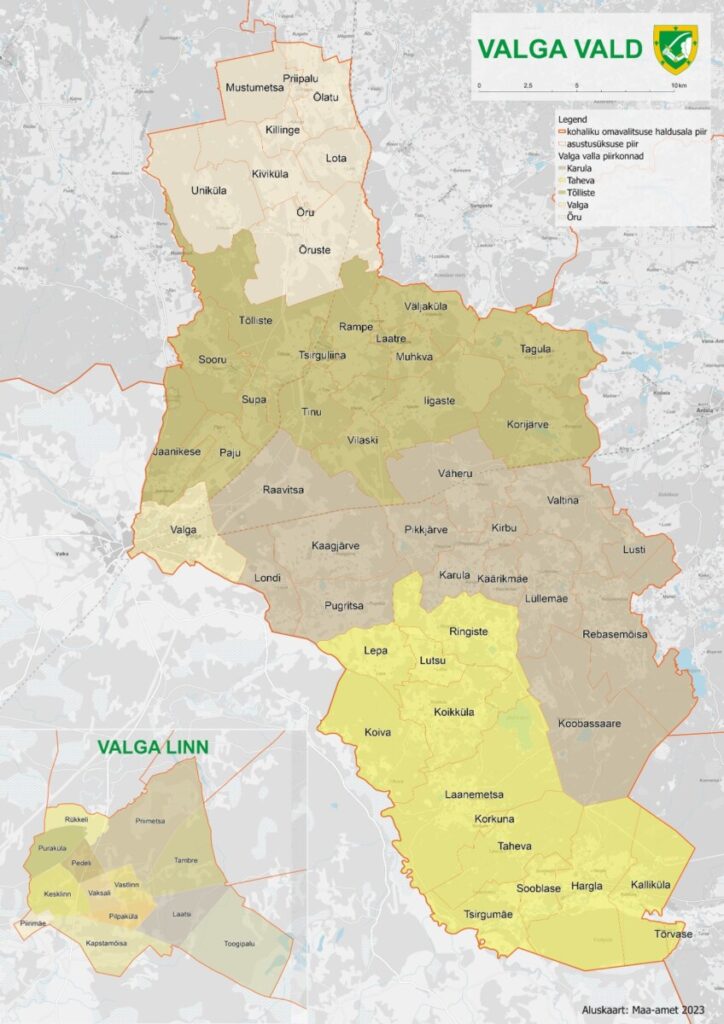
Valga municipality
Valga municipality was formed on 22.10.2017 by the merger of Valga city, Karula municipality, Taheva municipality, Tõlliste municipality and Õru municipality. The boundary of the municipality runs along the external border of the merged municipalities, in the south the municipality shares a border with the Republic of Latvia. Valga municipality covers an area of 745 km² and is bordered by the municipalities of Otepää and Tõrva in Valga County and the municipalities of Antsla and Rõuge in Võru County. The centre of the municipality is the historical county centre and the cross-border twin town of Valga. In addition to the town of Valga, there are three larger villages (Laatre, Tsirguliina and Õru) and 48 villages.
Valga municipality on map
Population of Valga municipality
The population of the municipality is concentrated mainly in the city of Valga and the Tsirguliina area, while the rest of the territory is covered by villages and rural settlements.
Nature and landscape of Valga
The landscape of Valga municipality is shaped by the Sakala, Otepää and Karula uplands, which are separated from each other by the Valga and Hargla hills. The central part of the municipality belongs to the area of undulating uplands and moraine hills articulated by the primeval organs of South Estonia. In the south-eastern part of Karula, on the Karula dome, lies Karula National Park, part of which is within the territory of Võru County. Established to protect heritage landscapes, the national park has a large number of lakes (over 40) and the largest forest massif in south-eastern Estonia. The landscape around Valga is flat, the town is situated on the banks of the Pedeli River. The southern part of the municipality is characterised by a highly fragmented landscape, with forested areas interspersed with villages, farmland, bogs and lakes. The major rivers in the municipality are the Arujõgi, the Koiva and the Mustjõgi.
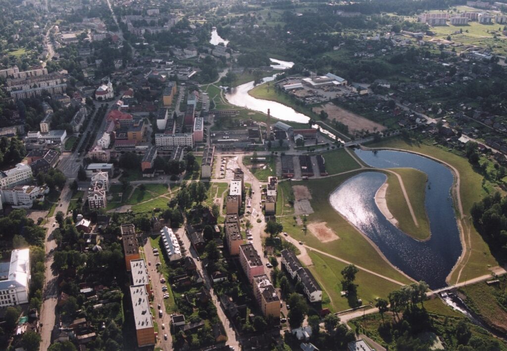
City of Valga
The city of Valga was first mentioned in documents of the Livonian Order in 1266, when it was called Walk. On 11 June 1584, King Stefan Bathory of Poland granted Valga a charter of incorporation and the city charter of Riga, which is considered the city's birthday. After the independence of Estonia and Latvia in 1918, the ownership of the town, which had become an important railway junction, became a bone of contention between the two countries, and an international commission under the leadership of British Colonel Tallent settled the dispute. Tallents made the foolish decision to divide the town between the two countries (legend has it that he cut the town in half on a map with his hand or a sword), and so in 1920 the twin towns of Valga/Valka were born. On 21 December 2007, both countries joined the Schengen visa area, which restored free movement between the two halves of the city. The introduction of the euro also increased trade. Close cross-border cooperation has developed between the municipalities of Valga and Valka, including joint events and projects. A joint Valga/Valka urban settlement is also under construction on the banks of the Konnaoja river, which runs through the city.
Taheva region
The Taheva area is located in the southern part of the municipality. Historically, it is part of the former Hargla parish in Vana-Võrumaa. There are 13 villages in the area. Taheva is known for its excellent berry and mushroom forests, with more than half of the area covered by forest. The Koiva-Mustjõe Landscape Reserve and the Koiva-Mustjõe Floodplain Conservation Area also lie within the territory. Taheva's nature is beautiful in all seasons. The "fifth season" is particularly enchanting, when the spring floodwaters flood the Koiva River floodplains. Important sights include the Hargla church and cemetery, the former Hargla inn and the Taheva manor buildings in the village of Tsirgumäe. Hargla's folk costumes are also well known..
Karula region
The larger villages in the Karula region are Lüllemäe and Kaagjärve. Karula is rich in forests and lakes, and the area is home to picturesque swimming and fishing spots. The Karula National Park has been created to protect the area's diverse heritage landscapes. The village of Lüllemäe is home to the former Karula parish church, which has a memorial in its garden to the writer and statesman Jaan Lattik, whose birthplace, Mägiste, is nearby. Kaagjärve and Karula manors are surrounded by beautiful parks. The main building has been preserved in Kaagjärve, while in Karula the manor's manor house is of interest. The Karula region is an active promoter of popular sports, with local initiatives such as cycling routes, walking tours and orienteering. In winter, the Lüllemäe also has a ski slope with a lift, tuba rental and cross-country skiing trails.
Tõlliste region
The Tõlliste region has two towns, Tsirguliina and Laatre, and 13 villages. The area is located in the flat Valga hollow between the Sakala, Otepää and Karula uplands, drained by the Väike Emajõgi and its tributaries (Pedeli, Laatre, etc.). In the lowest part of the river meadow is the Korva meadow, which is a drained experimental meadow of the former Sangaste manor, where a rare species of rush grows. Tõlliste is an active agricultural area, where the majority of farmers are engaged in traditional farming (livestock and cereals). Alternative forms of farming (berry growing, sheep farming, herb growing, etc.) are also emerging. Fertile farmland and woodland also leave ample scope for future development.
Õru region
The Õru region is located in the heart of Valga County, historically belonging to the parish of Sangaste. Its larger settlements are the historical centre Priipalu and the former parish town Õru. There are eight villages in the area and the main activities are forestry and agriculture. Õru values a pleasant living environment and active outdoor pursuits. To this end, the community has cleaned up recreational areas and built a disc golf course, a volleyball court and a universal sports field with tennis facilities in Õru. There is also a low-altitude trail for those interested. Together, they are building village parks and young people are spending time in the Youth Hostel.
Regional service centres
To ensure access to essential services, a system of service centres has been created in the municipality following the administrative reform. The municipality has four service centres with a regional secretary, a child protection specialist, a social work specialist and a care specialist: Karula service centre in the village of Lüllemäe, Taheva service centre in the village of Hargla, Tõlliste service centre in the village of Tsirguliina and Õru service centre in the village of Õru.